print


03.11.2017.

New situational plan and new cell of Electronic Navigational Chart for the Sava River for sector Kamičak available.

Sektor Kamičak

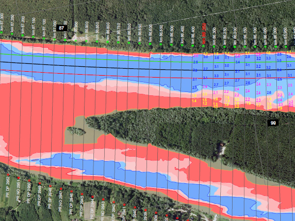
In period July – October, Directorate for Inland Waterways performed sediment dredging at critical sector Kamičak on the Sava River, on the section km 86.3 – km 84.8. With sediment dredging, dimensions of the waterway which enable the safe navigation in periods of low water, are provided. Dredged sediment was returned to the riverbed in accordance with the principle of preserving the sediment balance.

The new situational plan for critical sector Kamičak, including available depths with reference to the low navigational level, can be downloaded from the web page Navigational Bulletin, in PDF format.

Beside new situational plan, the Directorate for Inland Waterways has prepared and published the new cell of Electronic Navigational Chart for the Sava River containing stretch of the critical sector Kamičak, in Inland ECDIS standard 2.3. The new cell of Electronic Navigational Chart contains data on available depths of fairway at this sector with reference to the low navigational level, based on latest results of hydrographic survey, conducted in October 2017, position of the fairway and up-to-date system of waterway marking.

For dynamic data on available depths of fairway on the critical sectors, please visit the Navigational Bulletin, information service for providing up-to-date dynamic data on waterways in the Republic of Serbia, where international and interstate navigation regimes are applicable (Danube, Sava and Tisza). This service is available in Serbian, English, German and French language.


Nazad


Keywords:
dredging, sava, river, critical, sector, kamicak


Related news:

12.02.2010 Plovput at GIS Forum Danube Held in Vienna
06.01.2010 Plovput in Serbian Delegation at Meetings related to EU Strategy for Danube Region
02.10.2009 Plovput Finished the Sava River Marking Campaign for 2009
14.10.2009 Serbia and Croatia Signed Bilateral Agreement on Navigation and IWW
30.10.2009 Plovput at FP7 Info Day
05.10.2009 Plovput Continues to Modernize IWW Marking System
17.06.2019 Plovput published the new edition of the Danube River Navigational Char
06.08.2018 Changes of available dimensions and dislocation of the fairway on the critical sector Futog
14.06.2019 New edition - Atlas of Berths for Danube, Sava and Tisza
24.12.2018 New Electronic Navigational Charts for the Danube River
27.12.2018 Plovput published Navigational Chart of the Danube River
13.12.2018 Plovput published Navigational Chart of the Tisza River
13.12.2018 New Electronic Navigational Charts for the Tisza River
06.12.2018 New layouts of the critical sectors on the Sava River
04.12.2018 New Electronic Navigational Charts for the Sava River
04.12.2018 Plovput published Navigational Chart of the Sava River adjusted for printing in A4 format
07.11.2018 Study visit of the cadets of the Military Academy of the University of Defence
13.09.2018 Beginning of the works execution under the project "River Training and Dredging Works on critical sectors on the Danube River"
19.06.2023 General repairs of the Serbian lock Iron gate 2
04.07.2019 Changes of available dimensions and dislocation of the fairway on the critical sector Futog
05.07.2019 New Edition of the Danube Glossary
08.11.2019 Study visit of students of the Faculty of Transport
28.11.2019 The new layout of the critical sector Futog
30.12.2019 Plovput published Navigational Chart of the Sava River
30.12.2019 Plovput published Navigational Chart of the Tisza River
30.12.2019 New Electronic Navigational Charts for the Tisza River
30.12.2019 New Electronic Navigational Charts for the Sava River
30.12.2020 Plovput published the new edition of the Danube River Navigational Chart
30.12.2020 Plovput published Navigational Chart of the Sava River
30.12.2020 New Electronic Navigational Charts for the Danube River
30.12.2020 New Electronic Navigational Charts for the Sava River
30.12.2016 ENC for the Danube River in Inland ECDIS standard 2.3
23.11.2015 New Electronic Navigational Charts for the Danube River
01.03.2016 Plovput published new Electronic Navigational Charts for the Sava River
22.03.2016 Plovput published second edition of navigational chart for the Danube River
05.07.2016 Plovput published new Electronic Navigational Charts for the Tisza River
05.07.2016 Plovput published Navigational Chart for the Tisza River adjusted for printing
03.08.2016 Plovput published new situational plans of critical sectors for navigation on the Sava River
07.09.2016 Mihajlović and Bulc about using the potential of the Danube and EU project support in water transport
13.09.2016 At critical sector Futog fairway dislocated and narrowed
17.09.2016 New Electronic Navigational Charts for the Sava River
30.09.2016 5.7 million tons of cargo transported by waterways in the first 6 months of 2016
09.12.2016 New functionality of Navigational Bulletin available to waterway users
14.12.2016 New Electronic Navigational Charts for the Tisza River
12.06.2018 The Second METEET Workshop held
12.02.2017 The regime of daily navigation established on the entire Danube
13.02.2017 Plovput published the third edition of Navigational Chart for the Danube River
12.06.2017 Changes of available dimensions and dislocation of the fairway on the critical sector Futog
14.06.2017 Waterway marking system on the construction site of new bridge on the Sava River updated
14.07.2017 Plovput published Navigational Chart of the Sava River adjusted for printing

RSSPlovput FacebookPlovput TwitterPlovput InstagramPlovput Youtube


download documents

Informer

Photo Gallery

newsletter


Stakeholders' Forum

Danube Glossary 2019


Danube Stream